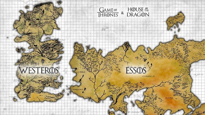
A map of Game of Thrones depicts the fictional continents of Westeros and Essos, showcasing the diverse kingdoms, cities, and geographical features crucial to the series’ events.
Ever felt lost in the vast world of Westeros and Essos? Navigating the intricate political landscape of Game of Thrones can be challenging without a proper guide. That’s where a map of Game of Thrones becomes essential for truly appreciating the show’s narrative complexity.
This visual tool not only provides a clear geographical understanding of the Seven Kingdoms, but also the locations of key events and the journeys of our favorite characters. Exploring a map of Game of Thrones brings the story to life in a completely new way.

A Map of Game of Thrones: Exploring the Lands of Westeros and Beyond
Have you ever looked at a map and wished you could just step right into it? Well, when it comes to the world of Game of Thrones, that feeling is very strong. The lands of Westeros and the areas beyond are so rich with history and interesting places. A map isn’t just a picture, it’s your guide to understanding all the stories in Game of Thrones. Let’s journey through this incredible fictional world, place by place, and get a good look at what makes each location so special.
Westeros: The Seven Kingdoms and Beyond
Westeros is the main landmass where most of the action happens in Game of Thrones. It’s often called the Seven Kingdoms, but things aren’t quite that simple. Let’s explore each main region and see what makes them different.
The North
The North is huge! It’s the biggest of the regions in Westeros and it’s also the coldest. If you could visit, you’d find thick forests, snowy mountains, and brave people. The people of the North are known for their strong sense of honor. Winterfell, home of the Stark family, is their main castle. The weather here is often harsh, and the saying “Winter is Coming” is something the Northerners take very seriously.
Important places in the North include:
- Winterfell: The Stark family’s home. It’s a big, old castle with tall walls to keep out the cold.
- The Wall: A massive wall of ice that protects Westeros from wildlings and other dangers from the far north. It is said to be made of magical ice that no fire can melt.
- The Dreadfort: The creepy home of the Bolton family, known for their cruelty.
- White Harbor: The biggest port city in the North, and it is where the North connects with rest of the world.
The Riverlands
The Riverlands are in the center of Westeros, and they’re always being fought over. Think of it like a crossroads that many armies pass through, this often leads to trouble. The Riverlands is known for its fertile lands and many rivers. It’s home to many small lords, and Riverrun, the ancestral home of the Tully family, is here.
Key features of the Riverlands:
- Riverrun: The Tully family castle, built where three rivers meet. It is a strong castle.
- The Twins: Two castles that control a critical bridge over a major river. It is the seat of House Frey.
- Harrenhal: A massive, ruined castle with a dark history.
The Vale of Arryn
The Vale of Arryn is a mountain region to the east of the Riverlands. It’s surrounded by high mountains, making it hard to reach. The Eyrie, the Arryn family’s castle, is built way up high in the mountains. This makes it very hard to attack, but also quite isolated.
Key features of the Vale:
- The Eyrie: The Arryn family castle, built on top of a tall mountain.
- The Bloody Gate: The main entrance into the Vale, a narrow pass that’s easy to defend.
The Westerlands
The Westerlands are rich in gold mines. The Lannister family, who are very rich and powerful, call this place home. The Westerlands are located to the west of the Riverlands and are known for their rugged hills and fertile valleys.
Important places in the Westerlands:
- Casterly Rock: The Lannister family’s main castle, built on a big rock overlooking the sea.
- Lannisport: The main port city of the Westerlands and a very important trading center.
The Reach
The Reach is the most fertile and richest region in Westeros. It is south of the Westerlands. This place is known for its beautiful gardens and plentiful food. It is considered the most prosperous kingdom in the seven kingdoms. The people here have a reputation for kindness and courtesy, it’s home to the Tyrell family, known for their beautiful flowers.
Important places in The Reach:
- Highgarden: The Tyrell family’s main castle, known for its gardens.
- Oldtown: The biggest city in the Reach and a center of learning.
The Stormlands
The Stormlands are a wild and stormy region to the south of the Reach. The coastline here faces the sea, and powerful storms often sweep through. The people here are known for being tough and strong. It’s home to the Baratheon family. The main castle is Storm’s End.
Important places in the Stormlands:
- Storm’s End: The Baratheon family’s home, a very strong castle built on the coast.
The Crownlands
The Crownlands aren’t controlled by one of the major families. Instead, the King rules this region directly. King’s Landing, the capital of Westeros, is located here, where the Iron Throne sits. It’s located on the eastern coast of Westeros and consists of the lands directly surrounding King’s Landing.
Key features of the Crownlands:
- King’s Landing: The capital city of the Seven Kingdoms and home to the Iron Throne.
- Dragonstone: A volcanic island fortress that used to be the Targaryen family’s home.
Dorne
Dorne is a hot, desert region in the far south of Westeros. It’s different from the rest of Westeros. It has its own culture, which is influenced by the Rhoynar people who came here a long time ago. The people of Dorne are known for their love of passion and strong sense of independence. Sunspear, the Martell family’s castle, is located here.
Important places in Dorne:
- Sunspear: The Martell family’s main castle, known for its hot and dry climate.
- The Water Gardens: A beautiful place in Dorne with pools and fountains.
Beyond Westeros: Exploring Essos and Other Lands
Westeros isn’t the only place in the world. There is also Essos, a big landmass to the east. Here, you will find many different cities and cultures. The lands beyond Westeros are even more diverse, from the hot deserts of Essos to the frozen lands in the far north. Let’s take a look at some of these important areas.
Essos
Essos is a large continent east of Westeros. It’s a vast and varied land with many different regions and cultures. It includes the Free Cities, the Dothraki Sea, and Slaver’s Bay, among other regions.
The Free Cities
The Free Cities are a group of nine independent city-states on the western coast of Essos. These cities are known for trade and wealth, and many of them were founded by people who left the Valyrian Empire long ago. Each city has its own unique culture and government, making the area very diverse.
Important Free Cities include:
- Braavos: A city of canals and secrets, known for its powerful bank and skilled assassins.
- Pentos: A city of merchants and trade, where Daenerys first begins her journey.
- Volantis: The oldest and most powerful of the Free Cities, with a strong army.
The Dothraki Sea
The Dothraki Sea is a large area of grasslands in the center of Essos. The Dothraki are a nomadic group who live there and are known for their skill on horseback. It’s not really a sea of water, but a sea of grass.
Key things about the Dothraki Sea:
- Vaes Dothrak: The Dothraki’s only city, where all the khals (leaders) meet. It is considered a holy place for them.
Slaver’s Bay
Slaver’s Bay is a region on the southern coast of Essos. This place is known for its history of slavery, and the cities here are very rich because of it. This area is ruled by slavers and nobles. Daenerys Targaryen comes here to free the slaves.
Important places in Slaver’s Bay:
- Astapor: A city known for its unsullied slave soldiers.
- Yunkai: Another major city in the slave trade.
- Meereen: The largest city in Slaver’s Bay, which Daenerys conquers and tries to rule.
The Red Waste
The Red Waste is a vast, barren desert located east of Slaver’s Bay. This region is very hot and dry, making travel difficult. Daenerys and her followers must pass through here. It’s not a place where many people live.
Qarth
Qarth is a rich port city in Essos, known for its powerful merchants and its strange customs. It’s located along the southern coast, east of the Red Waste. Qarth is famous for its beauty and its powerful rulers. Daenerys travels here in her quest to reach the seven kingdoms.
The Lands of Always Winter
The Lands of Always Winter are located in the far north of Westeros. This is a mysterious area where it’s always winter. It’s said to be a place of magic and danger, where the White Walkers live. This place is cold and dark and not good for humans.
Key features of the Lands of Always Winter:
- The land is always covered in snow and ice.
- It is home to the White Walkers and other dangers.
Different Perspectives on the Map
It’s interesting how the map of Game of Thrones can change depending on who you ask. For example, a lord in the North sees the world differently than a merchant in Essos. This is because each person only knows what’s in his region. They may not know all about another region, because the world is so big. Here’s what we mean:
- A Northerner: Might see the world as very cold and dangerous, with the Wall as the only real boundary.
- A King’s Landing Noble: Would think of the world from the Iron Throne perspective. The lands are ruled by the king and they are the center of the world.
- A Dothraki: They would think of the world as a huge plain, where they roam free. They are not familiar with cities or castles.
Understanding the Map: Why It Matters
The map of Game of Thrones isn’t just a picture; it helps to understand the stories. The world itself plays a role in the lives of the characters. When we see where a character is traveling to, it tells us a lot about their goal or the challenges they’ll face. It tells us more about the regions, and the people who live there.
For example:
- Knowing that the North is cold explains why the people of Winterfell are so tough.
- Understanding that the Riverlands are fought over often, helps to understand why the people are often at war.
- Knowing that Dorne is a desert makes us understand why their culture is so different from the other kingdoms.
The map of Game of Thrones is a doorway into the stories. It provides context to the various conflicts, alliances, and adventures throughout the series. It reminds us that the world is much bigger than one kingdom, and that each region plays an important role in the grand scheme of things. By looking at the map, we can follow the story, plan our own adventures, and appreciate all the beautiful lands of the game of thrones world.
Game of Thrones World Map EXPLAINED
Final Thoughts
Understanding Westeros and Essos becomes much easier with a map of game of thrones. The vast distances and varied kingdoms make geographical comprehension vital for following the intricate plot lines.
This visual guide helps trace character journeys and strategic military movements. Therefore, a map of game of thrones enhances the viewing experience significantly, offering necessary context. This crucial element enhances immersion.

